How two new California wildfires look from space
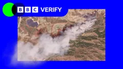
Two new wildfires have erupted in California, with significant spread observed in satellite images. The Sandy Fire in Simi Valley has prompted the evacuation of over 10,000 homes, while a separate fire on Santa Rosa Island has burned 14,600 acres. Firefighting efforts are ongoing, with support from helicopters and ground crews.
- ▪The Sandy Fire ignited in Simi Valley and has spread across 1,364 acres with no containment.
- ▪More than 10,000 homes have been evacuated due to the Sandy Fire, with an additional 3,500 homes under evacuation warnings.
- ▪A separate fire on Santa Rosa Island has burned 14,600 acres and remains uncontained.
Opening excerpt (first ~120 words) tap to expand
How two new California wildfires look from space43 minutes agoShareSaveAdd as preferred on GoogleThomas CopelandBBC VerifyBBCSatellite images have revealed the scale of two wildfires spreading in southern California.The Sandy Fire ignited on Monday morning in the city of Simi Valley, north-west of Los Angeles, according to California Governor Gavin Newsom.Satellite images taken just after noon local time (20:00 BST) on Monday show a large plume of smoke rising into the air just south of the city.California fire officials said on Tuesday morning that 750 firefighters were being supported by "night-flying water dropping helicopters" to target hotspots.
…
Excerpt limited to ~120 words for fair-use compliance. The full article is at BBC News.
Discussion
0 commentsMore from BBC News