Farming in Ancient Lake Agassiz

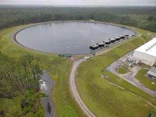
Lake Agassiz, which existed around 15,000 years ago, created fertile farmland in southeastern Manitoba. The nutrient-rich silt and clay left by the lake continue to support productive agricultural landscapes today. A recent photograph from the International Space Station highlights the region's farming and natural features.
- ▪Lake Agassiz was larger than all the Great Lakes combined and formed in front of the retreating Laurentide Ice Sheet.
- ▪The lake began draining approximately 12,000 years ago, leaving behind a legacy of fertile farmland.
- ▪The Dominion Land Survey divided much of western Canada into one-square-mile sections, influencing the layout of farm fields and roads.
Opening excerpt (first ~120 words) tap to expand
Earth ObservatoryScienceEarth ObservatoryFarming in Ancient Lake AgassizEarthEarth ObservatoryImage of the DayEO ExplorerTopicsAll TopicsAtmosphereLandHeat & RadiationLife on EarthHuman DimensionsNatural EventsOceansRemote Sensing TechnologySnow & IceWaterMore ContentCollectionsGlobal MapsWorld of ChangeArticlesNotes from the Field BlogEarth Matters BlogBlue Marble: Next GenerationEO KidsMission: BiomesAboutAbout UsSubscribe🛜 RSSContact UsSearch 3 min readFarming in Ancient Lake AgassizImage of the Day for May 19, 2026The glacial lake left a layer of silt and clay in southeastern Manitoba, creating fertile farmland that was divided during 19th-century land surveys and is still farmed today.NASA Earth ObservatoryMay 19, 2026 Article View more Images of the Day:May 18,…
Excerpt limited to ~120 words for fair-use compliance. The full article is at NASA — Breaking News.
Discussion
0 commentsMore from NASA — Breaking News